Freeing a Trapped River
Celebrating 10 years of restoration, partnership and the largest ecological restoration in Maryland’s history.
For the past 10 years, The Nature Conservancy in Maryland/DC and our partners have been working to reconnect the Pocomoke River to its natural and historic floodplain.
As we mark the 10-year anniversary of the project’s formation, we celebrate the accomplishments that make this project the largest ecological restoration in Maryland’s history. Our partnership has restored more than 3,000 acres of floodplain along 14 miles of the once-channelized stretch of river, creating a model for large-scale wetland restoration in the Bay.
The Pocomoke River Restoration Partnership has been the result of a substantial and ongoing collaboration between numerous partners, including the U.S. Department of Agriculture’s (USDA) Natural Resources Conservation Service (NRCS), U.S. Fish and Wildlife Service (USFWS), the U.S. Geological Survey (USGS), Delaware Wildlands, Ducks Unlimited, the France-Merrick Foundation, Toms of Maine, and the National Fish and Wildlife Foundation (NFWF), as well as the cooperation of many local landowners.
Learn more about the history and outcomes of this remarkable effort in the story and videos below.
Floodplain Wetlands: A Critical Role
Floodplain wetlands play a critical role by storing and filtering water. During large storms, rivers like the Pocomoke overflow their banks into the adjacent lands, or floodplain.
The water spreads out and is slowed by vegetation. Sediment settles out of the water, and nutrients are absorbed by plants and trees. The Pocomoke floodplain’s saturated soils support some of the most biodiverse wetland habitats in the region.
After the storm, when the river’s water level subsides, the filtered floodwaters slowly return to the river. The whole process helps to reduce erosion and improve water quality.
Draining the Swamp
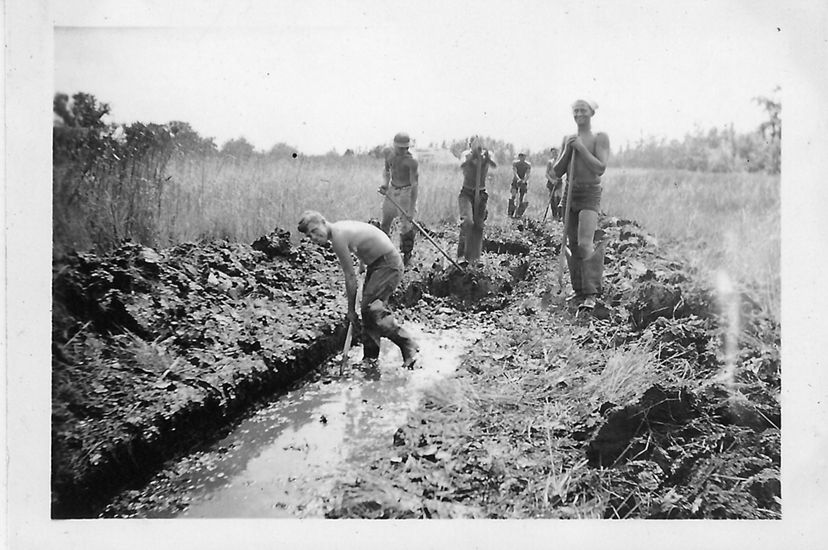
The 73-mile-long Pocomoke is the easternmost river that flows into the Chesapeake Bay, draining water from four counties in Delaware, Maryland and Virginia. Ditching the land for agriculture began during the colonial era but dramatically increased post-World War II to meet the food demands of a booming population.
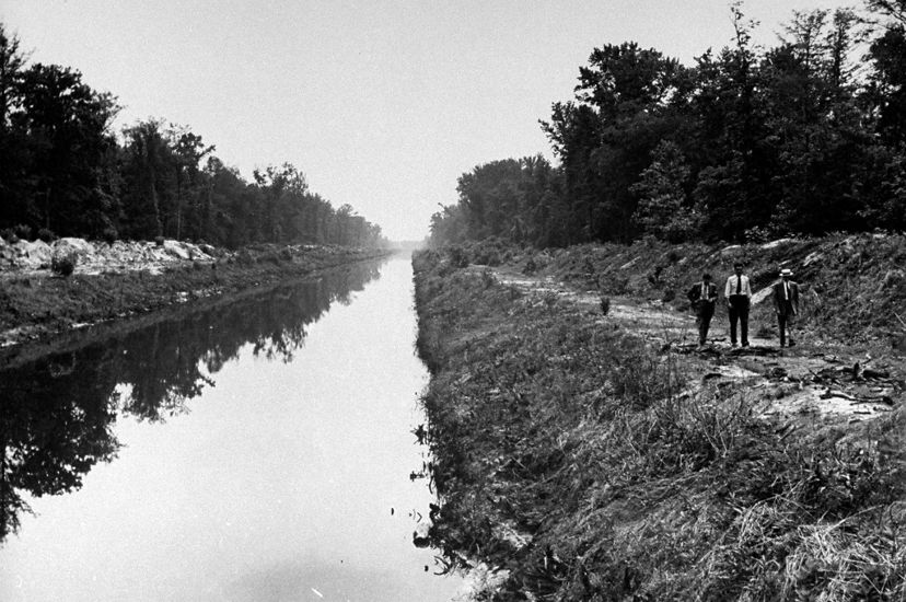
While the surrounding cropland was being ditched to more rapidly transmit water off the land after heavy storms, an 18-mile section of the Pocomoke River mainstem was dredged and channelized. The dredged material was piled along each side of the river’s edge creating spoil banks, further disconnecting the river from thousands of acres of floodplain.
The announcement of a ribbon-cutting ceremony initiating the dredging of the Pocomoke in 1946 provides a perspective from Delmarva at that time:
“The flat farmland in this area must be drained by ditches which empty into the Pocomoke River. After hard rains the water backed up into the drainage ditches, and fields were sodden for days, making the ground barren and unprofitable as farmland.”
Quote: Celebration of Pocomoke Draining Project
After hard rains the water backed up into the drainage ditches, and fields were sodden for days.

Today, consequences of the Pocomoke Drainage Project are apparent. The ditching of the floodplain, and the channelization of the river, converted what was historically a groundwater-dominated system into a surface water-dominated system.
The channelized Pocomoke transmits water more rapidly off the land and into the Chesapeake Bay, without giving the full floodplain the opportunity to filter nitrogen, phosphorous and sediment—major contributors to dead zones in the bay, which can suffocate marine life.
The largest dead zone is most pronounced in the deep waters of the bay’s mainstem during warm summer months. Between 1985 and 2010, the duration of the dead zone fell from five months to four, suggesting efforts to manage nutrient pollution are working. The 2016 dead zone was smaller than average because of low river flow and reduced springtime nutrient-rich runoff. Restoration efforts like the Pocomoke will help even more.


Freeing a Trapped River
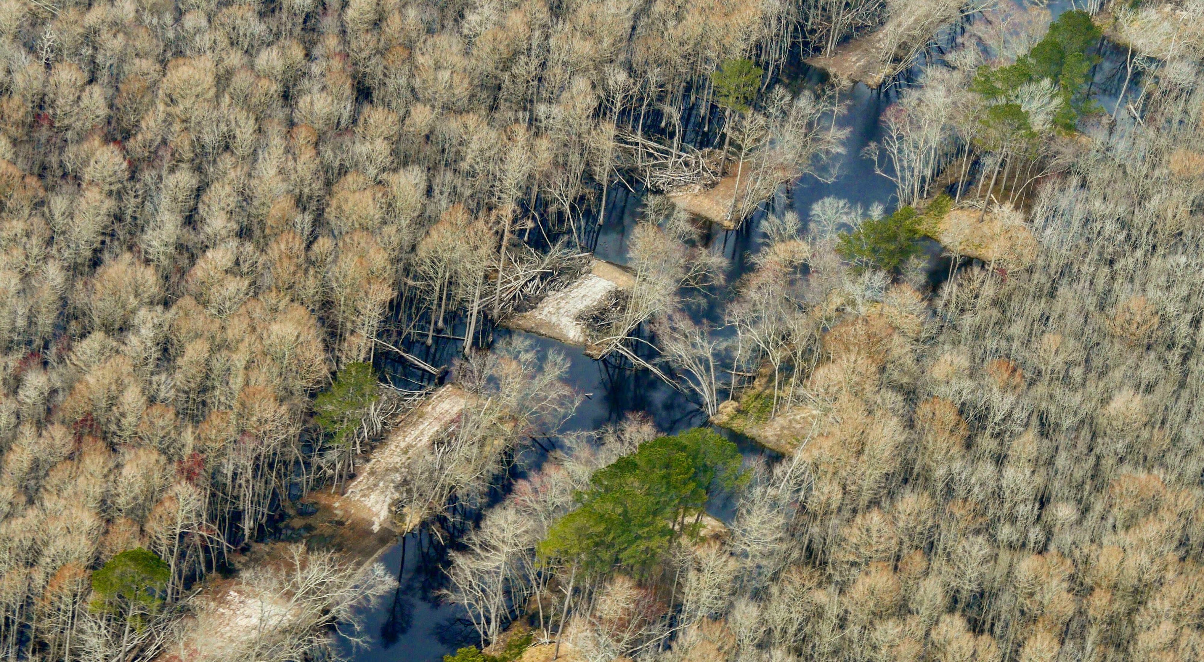
In 2017, partners came together to restore an initial section of the channelized portion of the Pocomoke River while not impacting the needed drainage to residents upstream. The scale of the Pocomoke floodplain restoration project is massive—encompassing roughly 4,000 acres of floodplain along 9 miles of the river.
The restoration itself focused on a narrow band of dirt—the spoil banks—which were piled over 12 feet high in some areas along the river’s edge during earlier dredging operations. Heavy construction equipment was brought in and operated by local contractors to carve more than 100 breaches—some up to 100 feet in length—through the spoil banks.


Working with Partners
The Pocomoke River Restoration Partnership has led to one of the largest ecological restoration efforts in Maryland’s history, and each partner plays a critical role: The NRCS secured easements and financial incentives for interested landowners and engineering of restoration; USFWS provided technical expertise to design effective restoration techniques; Maryland DNR provided project support and financial investment; and USGS monitored water quality.
TNC's work to advance outreach, implementation and monitoring was supported through the generous support of our private donors including the France-Merrick Foundation and the Maryland Chesapeake and Coastal Bays Trust Fund. NFWF has leveraged the great work of this project to support targeted restoration in other areas of the Chesapeake Bay.
Building on Success
In 2020, the success of the first phase of the restoration project helped lead to a new grant. Nearly $1 million from NFWF was awarded to accelerate wetland restoration across the Chesapeake Bay watershed.
The grant built on what worked in the Pocomoke: developing partnerships with key agencies and individuals, investing in capacity for outreach and providing flexibility to landowners with funding options to restore their land. The grant enabled TNC to coordinate with partners and landowners to design new, large-scale wetland restoration projects in Virginia’s Rappahannock watershed, in Pennsylvania’s Susquehanna River watershed and in Delaware’s Great Cypress Swamp at the headwaters of the Pocomoke River.
Quote: Amy Jacobs
We need to aim for ambitious public-private coalitions, engage more private landowners and use the best available science to tell us where restoration will provide the greatest benefits.
Connecting with People
People are always a critical component of the environmental conservation equation. With the number of federal, state and local government decision-makers involved, the private landowners whose participation is essential to the effort were at risk of being overwhelmed with information.
TNC invested the time to engage landowners to help them identify a restoration plan that works for them, whether that is enrolling in a government program, placing an easement on their property or entering into a private agreement with TNC. As one landowner partner noted, “The Nature Conservancy has been great to work with. They keep me informed when they’re working on the property, which is especially important during hunting season when we have a lot of people hunting on the property.”
Quote
We want to let them know that they’re restoring the land so that future generations can enjoy it.
Former TNC Restoration Specialist Mike Dryden, along with project partners, successfully engaged 24 landowners in the 9-mile stretch, enabling the restoration of 75% of the floodplain area.
“It’s really important to educate the community on this program, to make people feel comfortable about enrolling in the program. We want to let them know that they’re restoring the land so that future generations can enjoy it,” said Dryden.
Guided by Science
USGS began studying the Pocomoke River in 1998, ultimately finding that channelization made a significant impact on water quality in the Chesapeake Bay. TNC continues to collaborate with USGS and USDA scientists to further understand how floodplain function varies in relation to how near or far it is from the headwaters of the river and the health of the wetland.
At six sites along the Pocomoke River, a network of monitoring equipment installed in strategic positions evaluates restoration benefits: two monitoring devices are in sections of the river that remain channelized, three set along sections that have been restored and one set within a naturally connected river channel.
The monitoring program enables us to gather data on water level fluctuations and the impact the floodplain reconnection is having on flood reduction for downstream communities. The data will enable us to track how long water remains in the floodplains and the impact that natural storage and filtration process is having on water quality improvement for the bay. Initial monitoring results were exciting, indicating that this floodplain reconnection project is providing the anticipated benefits.

Life in a Cypress Swamp
There is one partner whose job is just getting started—nature itself will eventually take over.
The cypress swamp forest and wetlands that are fed by the Pocomoke’s natural flooding patterns are a biodiversity hotspot. The river itself, while altered, is home to numerous species of resident and migratory fish including herring and shad.
The Pocomoke watershed supports more than 60 recorded species of migratory songbirds, including high-priority species such as the wood thrush, Swainson’s warbler, Kentucky warbler, Louisiana waterthrush, worm-eating warbler, Acadian flycatcher, yellow-throated vireo, prothonotary warbler, red-headed woodpecker, barred owl and great-blue heron.
The wild and scenic Pocomoke River also drives a tourism industry that has become one of the largest economic sectors in Worcester and Wicomico counties. The state parks, state forests, wildlife management areas and nature preserves bordering the 73-mile-long river offer recreational activities almost as varied as the species that inhabit the swampy floodplain.
Restoring the river’s natural beauty and preserving the watershed’s fragile and captivating ecosystem is in everyone’s best interest.
We Can’t Save Nature Without You
Sign up to receive monthly conservation news and updates from Maryland/DC. Get a preview of Maryland/DC's Nature News email.

Recent Stories

Regenerative Agriculture in Maryland
Supporting an agricultural economy where farms provide healthy food, clean water and resiliency to climate change and support a healthy Chesapeake Bay.

Planting Atlantic White Cedar
A decade-long partnership between The Nature Conservancy and the National Aquarium is returning native Atlantic white cedar to Maryland's Eastern Shore.

Putting Down Roots with Native Plants
Our garden guide will help you choose plants native to the mid-Atlantic region, supporting pollinators and biodiversity.