Bringing the Marsh Back Home
A wetland restoration project in Louisiana promises to revive the Lake Pontchartrain shore.
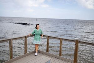
As a schoolgirl in the 1980s, Jennifer Van Vrancken loved to ride her Schwinn bike along the Lake Pontchartrain shore while her dad jogged next to her. Her family home in Metairie, La., a community that abuts New Orleans, sat one block from the lakefront. The lake’s brisk breezes and catches of shrimp and crabs, unloaded at Bucktown Harbor, were a welcome feature of life growing up.
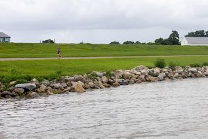
Nowadays, the lakefront is no longer as inviting. After Hurricane Katrina wreaked havoc on the area’s aging levee system in 2005, the government poured billions into shoring up levees and other defenses. The upgraded levees have done their job—withstanding two Category-4 hurricanes and dozens of weaker storms—but practicality has come at the expense of charm. In Metairie, a 17-foot-high mound of treeless, sun-crisped grass separates the town from the waterfront, stretching for miles in either direction.
“Even though we have the tremendous hurricane risk reduction system that protects us, it did have the effect of walling us off,” Van Vrancken says. The lake, “used to be a much more integrated part of our life.”
Van Vrancken is now the councilwoman-at-large for Jefferson Parish, which includes Metairie and several other towns. From the day she took office, Van Vrancken was determined to bring families back to the lakefront. In recent years, aided by the federal government’s Inflation Reduction Act and Infrastructure Investment and Jobs Act, this vision has begun to come to life. Construction is underway for a mile-long restored wetland that will extend westwards from Bucktown. The project will beckon not only people, but also birds, fish and other wildlife looking for a safe place to raise their kids.
As with many Louisiana residents, Katrina is the cataclysm that divides Van Vrancken’s life into a “before” and “after.” When the storm struck, her family evacuated from Metairie to Memphis, Tenn., where Van Vrancken was working as a television news reporter.
While Metairie escaped the ruinous devastation of New Orleans, recovery there was still long and hard. “You have to start throwing out furniture and salvaging pictures and cutting sheet rock and living in a construction zone while you try to rebuild your life,” Van Vrancken says.
Motivated by the desire to provide accurate, reliable news as the floodwaters receeded, Van Vrancken moved back to Metairie after a decade away. “I came home to report because I didn't think there was going to be any greater story in my life than my hometown being destroyed.”
That same sense of duty is what drove her to get involved in local politics in 2010, and then run for parish council in 2015. After she was elected, she turned her sights to an underutilized plot of land and water between Bucktown Harbor and Bonnabel Park to the west. For Van Vrancken, the 40-acre parcel was a perfect “blank canvas” to build something that could draw young families back to Metairie.
What's happening to Louisiana's marshes?
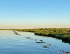
Since 1930, Louisiana has lost more than 2,000 square miles of wetland. This is due to engineering projects that have starved marshes of sediment carried by the Mississippi River, as well as land subsidence and storms. Sea level rise is now a growing threat, drowning marshes faster than they can grow.
A 2024 Tulane study found that nearly every monitored wetland along the state’s coastline was unable to keep pace with climbing water levels. Projects to recreate habitat and restore the Mississippi’s flow—along with efforts to halt planet-warming fossil fuel emissions—are now the only hope for the long-term survival of Louisiana’s marshes.
Van Vrancken worked with Lauren Averill, the parish’s coastal management director at the time, to come up with a living shoreline concept, which would pair restoration of the area’s long-vanished marshes with family-friendly attractions such as playgrounds and boardwalks. The revived wetland would also provide wildlife habitat and help buffer the town from storm surges.
Averill held meetings with scientists and the public to figure out how the project would work, and if it was something the community wanted. This was essential, given the project’s cost and scope. The reception was positive, and in 2017 Van Vrancken and Averill approached an engineering firm that had designed several other living shorelines.
After developing a $9-million plan that would incorporate storm resilience, habitat reconstruction and outdoor recreation, the next hurdle was funding. In 2019, the first money came in—a $250,000 design grant from the National Fish and Wildlife Foundation. This recognition of the project’s potential was what “got us rolling,” Van Vrancken says. After reviewing the design, NFWF gave the project another $2.5 million, through a National Coastal Resilience Fund grant.
With the pandemic’s arrival in 2020, labor and materials costs soared. Fortunately, more money was on the way, including $4 million from the Gulf of Mexico Energy Security Act, which channels leasing revenue from offshore oil and gas drilling to coastal restoration projects. The final $4.5 million came from the National Oceanic and Atmospheric Administration's Transformational Habitat Restoration and Coastal Resilience grant, made possible by the Inflation Reduction Act and the Infrastructure Investment and Jobs Act. Of the 200 coastal restoration projects that NOAA has funded, this would be the first one to protect a federal levee system.
A Day in the Life


Construction of the project’s nine rocky breakwaters—which create a still, sheltered stretch of water behind them—wrapped up in July of 2024. Sediment dredged from elsewhere in the lake will be used to fill this roughly 20-acre area, creating a rich, mucky bed to plant marsh vegetation once hurricane season has passed. Winding through the restored wetland will be a “blueway” for kayakers and other paddlers, who will push off from a newly constructed boat launch.
While the project will be complete in the next few months, it’s just the beginning of a broader effort to restore the area’s wetlands. Van Vrancken is in conversation with local officials in neighboring parishes to install additional breakwaters and marshes. Levee authorities view this a pilot project, she says, to determine whether the offshore rock buffers will do a better job of protecting the levees than the current approach of piling rubble at their base. “We all understand this is really the future of resilience,” Van Vranken says.
Quote: Jennifer Van Vrancken
We all understand this is really the future of resilience.
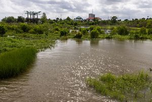
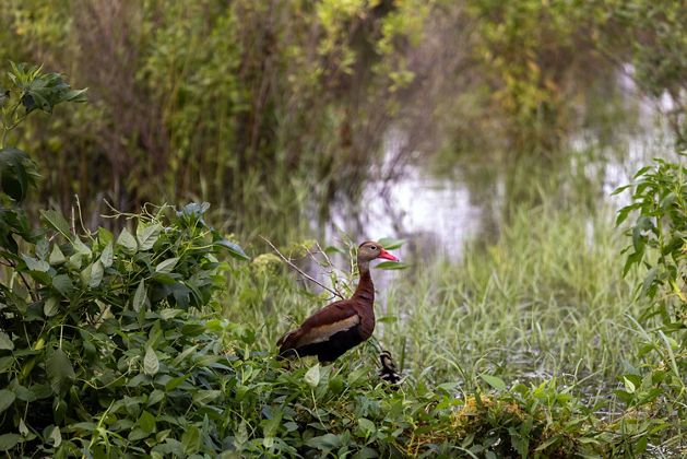
The nearby Bucktown Marsh, a 3.5-acre manmade wetland constructed in 2000, offers a verdant window into the future. Marsh grasses and blooming shrubs sprout from calm water where blue herons wade and black-bellied whistling ducks dabble. They are two of the 65 bird species that have been spotted here.
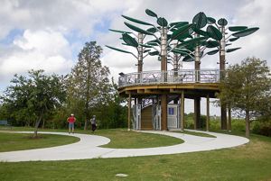
Overlooking the marsh is the Bird’s Nest Learning Pavilion, a Van Vranken brainchild that was completed in April 2023. From the top of the distinctive lookout platform, with its giant metal leaves that light up at night, visitors will be able to watch the Metairie shoreline come alive with new marshland in the coming years.
Seeing her vision for the lakefront gradually come to fruition has been “just amazingly fulfilling,” Van Vranken says. “It takes me back to childhood.”
Take Action
Government action on conservation is at an all-time high. We need to keep that going. Tell Congress to protect conservation funding today.

Stay in the Loop
Get conservation stories, news and local opportunities from where you live.
