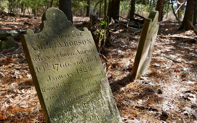
Joe Fehrer is racing against time and water. For the past year, Ferher has repeatedly visited a small gravesite on the water-logged Eastern Shore of Maryland, documenting everything he sees before the 10 graves of the Robson family cemetery slip into the rising sea. The graves, in land that once sat high and dry above the ocean, are now a mere eight feet from tidal wetlands.
Here, in the Mid-Atlantic United States, the ocean is rising 4 to 8 millimeters per year—estimated to be two to three times faster than the global average. The region, local experts say, is something of a canary in a coalmine for studying adaptation to sea-level rise. Communities on the “Eastern Shore,” a strip of coastline and barrier islands between the Chesapeake Bay and the Atlantic Ocean, are deciding how to adapt to more frequent flooding, harsher storms and subsiding land. Ecologists are studying how nature also reacts and adapts to new climate patterns to learn how it could help communities here and elsewhere. And long-forgotten cultural markers—the Robson family cemetery is one of many threatened by erosion—may soon be lost.
Fehrer, a former woodworker who specialized in historic preservation, couldn’t abide that for the Robson site, he says. “I’m a product of the Eastern Shore. This is my geography.”
Now a coastal projects manager for the nonprofit The Nature Conservancy, which owns the 900-acre Robinson Neck Preserve where the family cemetery was found, Fehrer will hand over all of his research into the gravesite and the family buried there to the Maryland Historic Trust. The trust will keep the information on file for future historians or descendants of the family.


Changing Landscape
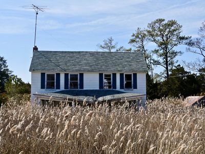
The land the Robson family cemetery sits on was once much farther from the tidal wetlands, says Fehrer. Today, a house foundation suggests a family home used to stand nearby. In the 1700s, when the Robson family migrated from England to colonial America, many people settled along the Eastern Shore’s coasts and barrier islands: With so few roads carved through the brush, waterborne travel made the coast a popular farming location.
The graves of those early farm families are scattered across the Eastern Shore. One threatened cemetery sits on Tangier Island in the Chesapeake Bay. Since the 1850s, Tangier has lost more than half its landmass to erosion. Another cemetery sits on Holland Island, which today is mostly underwater. The last permanent residents left in the 1920s. “The cemetery has fallen into the bay,” Fehrer says.
In most cases these types of watery gravesites can’t be moved or protected, Fehrer says. Walls would need to be built ever higher to keep the water out. And, anyway, preserving their location—keeping them in situ—is part of what gives them meaning, he says. But they can be noted for posterity. “To me, it’s about a visceral attachment to place,” he says. “I have no idea who these people were, but I feel a connection there because this is my place too.”


Modern Towns Adapt
Farther south along the Eastern Shore, in the village of Oyster, Virginia, plans are taking shape to help the community adapt to more frequent flooding. Already, Oyster is sometimes inundated several times a month, sometimes restricting access to the community when roads in and out flood.
“We’re seeing higher tides and sea levels and communities being flooded,” says Jill Bieri, the director of the Virginia Coast Reserve near Oyster. “Fifteen years ago, you thought of that as a hurricane event. Now you think of it as a nor’easter or just a full moon.”
The reserve, created by The Nature Conservancy, includes 14 undeveloped barrier islands that have historically helped block inland towns from storm surges.
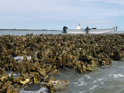
The Conservancy, which also owns land in Oyster, is helping the community consider options, such as restoring oyster reefs, to hold back the water and reduce erosion. Bieri says Oyster residents are concerned about road access, the loss of waterfront property due to erosion and decreased property values. In some cases, she says, “these [homes] are their life savings.” But there’s hope, she says, and learning what works here could help others.
“Because we are in that line of fire, what we’re demonstrating with our protected areas is how nature can play a role in adaptation strategies, Bieri says. “As we implement this plan for the village of Oyster, that’s something than can be shared with communities around the world.”

Coastal Refuge
Parts of the Eastern Shore are among the most intact coastal wilderness along the U.S. east coast. “All of this protected area [in the Virginia Coast Reserve], the barrier islands, the back-barrier marshes,” says Bieri, “those are intact and undeveloped. They still exist in their natural form.”
That helps the fishing and aquaculture industries that are huge in coastal Virginia, but it also helps sustain wildlife—the red knot migration, one of the longest bird migrations on Earth, passes through and relies on these beaches as a refueling stop. And, for Bieri and Fehrer, farther north in Maryland, that wilderness acts a climate research station.
At Virginia Coast Reserve, a long-term ecological research program began in 1987 through the University of Virginia. Since then it’s studied how climate change impacts human and natural communities on the Eastern Shore. What’s learned here, and farther north at Robinson Neck Preserve, where the Robson Cemetery is located, can help elsewhere, Bieri and Fehrer say.
For Fehrer, a former historic preservation woodworker turned landscape manager, documenting the past at the Robson Cemetery is one step. Now, he’s looking to what the woods at Robinson Neck Preserve can tell him about the future.
Get the Magazine
Sign up to become a member of The Nature Conservancy and you'll receive the quarterly print edition of the magazine as part of your membership.

